Lac-des-Cygnes Hike (The Ultimate Guide)

Welcome to Mont du Lac des Cygnes, one of Charlevoix’s most spectacular hikes!
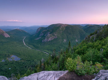
Located in the Grands-Jardins National Park, this summit rises to an altitude of 980 metres and offers breathtaking views of the Charlevoix astrobleme.
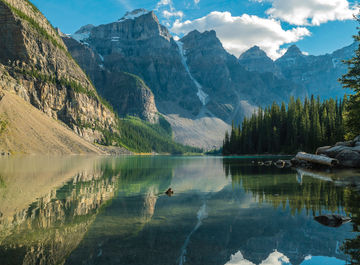
This 8.6-kilometre return trail takes you through a variety of unique landscapes, including taiga, tundra, and boreal forest. From the summit, you’ll enjoy a 360-degree view of the surrounding mountains and the majestic Lac des Cygnes.
How do you get there? When is the best time to go? What should you pack?
Here is your ultimate guide to planning a hike to Mont du Lac des Cygnes during your next visit to Charlevoix.
#1. What is the Mont-du-Lac-des-Cygnes hike?

 Main Characteristics
- Altitude: The summit reaches 980 meters.
- Distance: About 8.4 kilometers round-trip.
- Difficulty: Intermediate to difficult due to steep and rocky sections.
- Duration: About 3 to 6 hours round-trip, depending on walking pace.
The Mont-du-Lac-des-Cygnes hike is an iconic excursion located in the Grands-Jardins National Park, in the Charlevoix region of Quebec. It is a popular destination for outdoor enthusiasts and hiking lovers for its breathtaking panoramas and varied landscapes. You must not miss it on your eastern Canada tour!
From the summit, you can enjoy spectacular views of the Charlevoix region, including valleys, mountains, and sometimes even the St. Lawrence River on clear days. The trail crosses different ecological zones, ranging from coniferous forests to alpine landscapes.
The summit is an excellent opportunity for an iconic souvenir photo of Quebec's Great Outdoors.
#2. The trail
 Start of the Trail

The hike begins at the main parking lot of Grands-Jardins National Park. From the start, hikers are greeted with clear signage and information about the trail and the region. The first section of the hike winds through a dense conifer forest. This initial section is relatively gentle, allowing hikers to warm up and get used to the terrain. The majestic trees provide a shaded canopy, creating a serene and refreshing ambience.
The ground is mainly composed of compacted soil and small stones, making the hike pleasant. At this stage, you will be able to observe a variety of native plants, such as balsam fir, black spruce, and lush undergrowth of ferns and mosses. Songbirds, such as chickadees and thrushes, are often heard in this part of the forest.
After about 1.5 kilometres, the trail begins to incline more steeply. The ascent becomes more pronounced, and hikers may feel a slight change in difficulty. The trail remains well-maintained, but tree roots and rocks become more frequent. As you gain altitude, the view through the trees becomes more spectacular, offering glimpses of the surrounding mountains.
This intermediate section is ideal for photography enthusiasts, as the filtered light through the trees creates beautiful visual effects. Frequent breaks are recommended to hydrate and admire the scenery. The flora gradually changes with altitude, and it is possible to see alpine shrubs and colourful lichens on the rocks.
Middle of the Trail

About halfway through, the hike becomes a tad more technical and demanding. The trail transforms into a series of narrow and rocky switchbacks. This section requires particular attention and good physical condition. Hikers often need to use their hands to climb over larger, steeper rocks.
The views start to open up dramatically, offering panoramas of the Malbaie River valley and the surrounding mountains. Cliffs and rocky outcrops add a dramatic dimension to the landscape. On clear days, it is possible to see up to tens of kilometres. This part of the trail is also known for its diverse wildlife. Mountain marmots and birds of prey, such as hawks and eagles, are often visible.
After this arduous climb, you will reach a rocky plateau. This section offers a well-deserved break with flatter terrain and a 360-degree panoramic view. The landscape is characterized by rocky outcrops, colourful lichens, and resilient alpine plants. The wind can be stronger here, so it is advisable to wear windproof clothing.
This plateau is an ideal spot for a lunch break. Sit on the rocks and admire the raw beauty of the park. The silence is often interrupted only by the distant cry of a bird or the rustling of the wind through the rocks.
End of the Trail

The last section before the summit is a steep but relatively short climb of wooden stairs. This part of the hike is exposed to the elements, which means it can be colder and windier. Hikers must be prepared to face changing weather conditions.
Despite the difficulty, the final ascent is extremely rewarding. With each step, the view becomes more and more spectacular. The summit is getting closer and the anticipation is mounting. It's important to take your time, stay hydrated, and take regular breaks.
The summit of Mont-du-Lac-des-Cygnes is a well-deserved reward. At 980 meters above sea level, the view is simply breathtaking. Hikers are greeted by a vast expanse of wilderness, with panoramic views of the Charlevoix mountains, valleys, and sparkling water bodies.
Take photos, rest, and enjoy the tranquility of true nature. It's also a good spot for wildlife watching, with chances to see birds of prey in flight or caribou in the distance.
The return follows the same trail, but the descent offers a different perspective. Take time to appreciate the views you have missed on the way up and discover the flora and fauna in detail. The descent can be tough on the knees, so using trekking poles for added stability is recommended.
Althought the hike is classified as difficult, with good preparation and a spirit of adventure, this hike can be one of the most memorable of your life!
#3. What to bring?

For a safe and enjoyable hike, here is a list of what you should bring:
Clothing
- A fleece or an insulating jacket to keep you warm.
- A waterproof and windproof jacket to protect you from bad weather.
- A hat, gloves, and scarf for colder or windy days.
- Sturdy hiking shoes with good grip are essential. They should be well broken in to avoid blisters and provide good ankle support.
It is crucial to dress in layers to adapt to the temperature variations encountered in the mountains. Opt for moisture-wicking fabrics such as polyester or merino wool.
Food and Water
- Pack energy snacks like cereal bars, dried fruits, nuts, and chocolate. A light lunch, such as a sandwich, is also recommended.
- Bring at least 2 liters of water per person. Hydration systems like camelbaks can be very practical.
Equipment
- A comfortable backpack with adjustable straps and good ventilation.
- Including plasters, bandages, antiseptics, and personal medications.
- A park map, compass, or GPS to avoid getting lost.
- Sunscreen.
- Sunglasses.
- Wide-brimmed hat.
#4. How to access the Lac-des-Cygnes hike?

 Getting to the park
From Quebec City, take route 138 towards Charlevoix. In Saint-Urbain, turn onto route 381 towards Notre-Dame-des-Monts. The park is well signposted, and parking is available at the entrance.
Since the Lac-des-Cygnes hike is located in Parc national des Grands-Jardins, you will need to pay the national park entrance fees.
 2024 Rates
- Adult (18 years and older) : $9.85 per day.
- Child (17 years and under) : Free.
#5. Lac-des-Cygnes trail map

Frequently Asked Questions
How long does it take to hike Mont du Lac des Cygnes?
The Mont du Lac des Cygnes hike spans 8.6 kilometres round trip. An average walker completes the trail in 4 to 5 hours, including photo stops and observation breaks. The first section to Pioui Lake takes about 1 hour and 30 minutes. Experienced hikers may do it in 3 hours, while families with children might take up to 6 hours to fully enjoy the viewpoints.
When is the best time to do this hike?
The summer season, from June to September, offers the best conditions for this hike. July and August guarantee a clear trail and pleasant walking temperatures. It’s always a good idea to check the weather forecast the day before, as conditions can change quickly at altitude. To avoid holiday crowds, consider an early weekday outing.
Is the hike suitable for beginners?
Thanks to its well-maintained and clearly marked path, the first part of the Mont du Lac des Cygnes trail is ideal for beginner hikers. The wide and gently ascending trail allows you to walk at your own pace up to Pioui Lake. The climb becomes steeper after that point, but wooden walkways and steps help ease the ascent while protecting alpine vegetation.
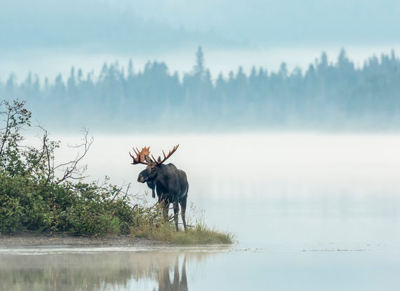
Can you see black bears in the park?
Black bears do live in the Grands-Jardins National Park. If you encounter one, stay calm and speak in a steady voice to make your human presence known. Do not run; instead, back away slowly while keeping the animal in sight. Maintain a distance of at least 50 metres and always leave the bear an escape route. To reduce the risk, hike in groups and carry bear repellent.
Do I need to book in advance to access the park?
To ensure access to Grands-Jardins National Park, online booking is highly recommended, especially during the busy summer season. Visit the Sépaq website to purchase your daily access pass. Without a booking, you may use the self-service kiosks at the Mont du Lac des Cygnes entrance, but card payment is sometimes unavailable when the service centre is closed.
There you go! You are now ready to ascend Mont-du-Lac-des-Cygnes.
For any questions or suggestions, feel free to express yourself in the comment section below.

About the author
![Karolane Lessard]()
Karolane Lessard
An enthusiast of both our vibrant cities & great oudoors, my life revolves around travel & adventure. It's a no brainer that I have to share the wonders & secrets of my neck of the woods with other travelling souls. Enjoy the journey!

An enthusiast of both our vibrant cities & great oudoors, my life revolves around travel & adventure. It's a no brainer that I have to share the wonders & secrets of my neck of the woods with other travelling souls. Enjoy the journey!


Leave a comment
Répondre à: -
delete my replyYour e-mail address will not be shared